Avebury Part 5/6 - The Silbury Hill, a separate story.
This limestone hill is an enigmatic eye-catcher and therefore deserves a separate story.
A few generalities.
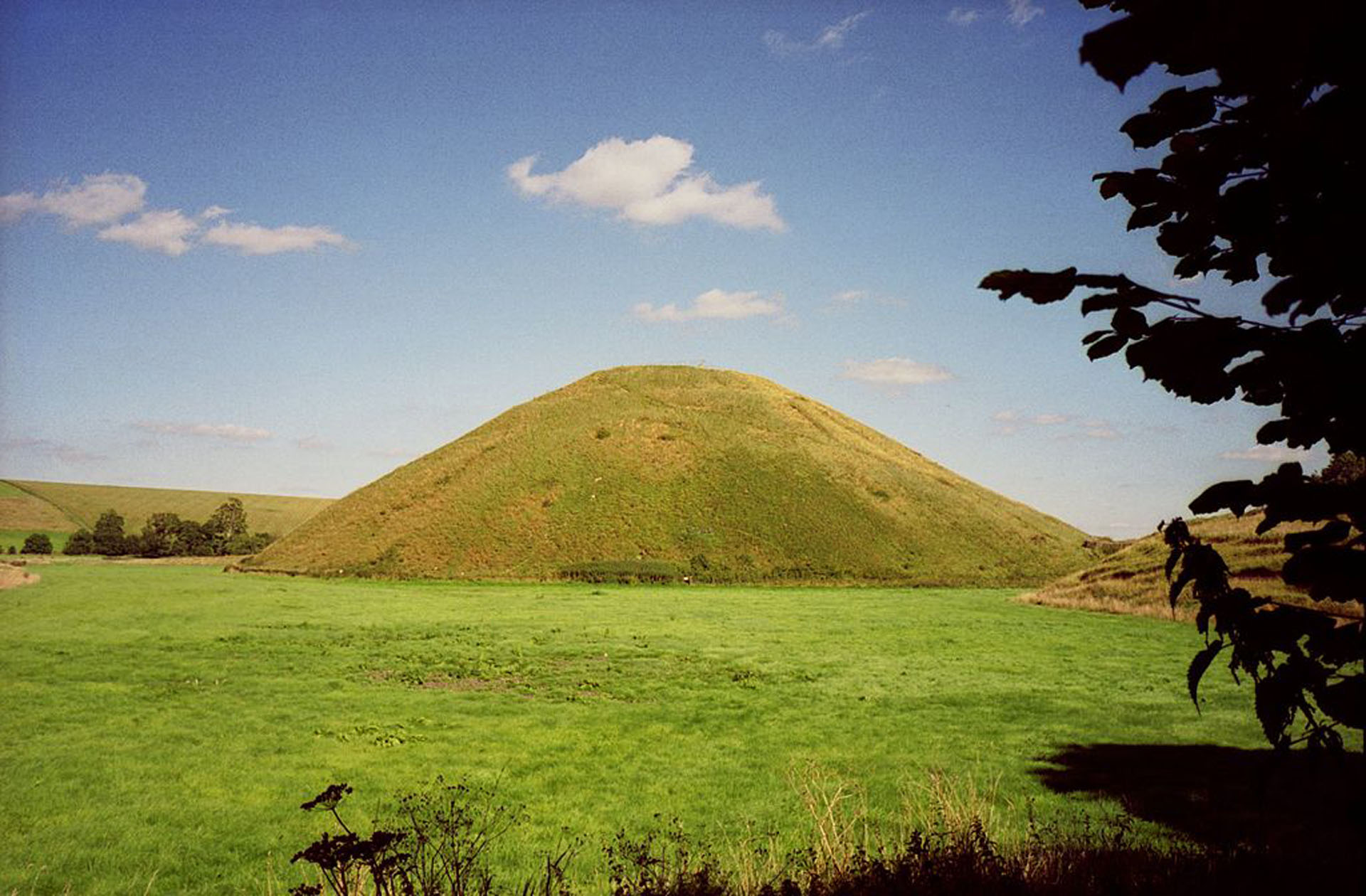
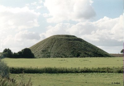
Two kilometres south of the Avebury Stone Circle is Silbury Hill Round Barrow. This is the tallest man-made hill in Europe:
- The height is 40 m.
- The diameter is 168 m.
- The perimeter is 0.5 km.
- In its 2 hectare ground area fit 3 full football pitches.
For some, this hill is the answer to the pyramids of Ancient Egypt. Age and size can be compared to each other, at least for the average smaller pyramids of Gizeh. Also in the construction there are intersections. But the hill is still shrouded in a greater haze of mystery than the pyramids. Extensive research has raised more questions than answers.
It used to be possible to climb the hill via a narrow path, but for understandable reasons this is forbidden today. Now there is a small car park at the bottom where you can enjoy the view for free. It is a real eye-catcher and you will find a lot of information on the signs.
Today the hill is overgrown and merges into the landscape. We must not forget, however, that it used to be a shiny white chalk hill, drawing all the attention to itself.
Esoterics point out that Silbury Hill is connected to other large archaeological sites such as Stonehenge via so-called Ley lines (or beneficial energy lines).
Construction.
The hill is dated by the radio-carbon method around 2700 BC. We are then fully in the Neolithic or New Stone Age.
The hill owes its stability to the fact that the builders applied a kind of honeycomb structure of limestone internally, no less than 500 000 tonnes were needed. Two large ditches were dug around the hill which probably provided the building material.
As far as the time span is concerned, there are two possibilities:
- Five hundred people could get the job done in fifteen years. A relatively short period of time in relation to the result. But it must be clear that if there is a period in which only half the work force is available, the construction will be delayed by half. The importance of the project can best be expressed in man-hours. An estimate of twenty million man-hours underlines the importance of the project.
- Provided that the hill is systematically raised, the work could be halted for a while after each level. In this way, the final fifteen years could be spread over several generations.
So a large group of people were motivated to make that effort. The leaders at the time managed to group their workforce and align them with the project.
There is no doubt that man at that time had few resources at his disposal. Deer antlers were certainly used as a pickaxe to chop limestone pieces loose.
Men assumes that the hill was built in phases and thus systematically raised. Those layers and those levels must have been more visible in the past, the current silhouette is rounded off and smooth due to erosion:
- The surface was demarcated and flattened. Thick sarsenkeien against the outer edge provided the necessary stability. Then came a thick layer of boulders and gravel. There’s no indication that that surface has been tinkered with.
- Subsequently, successive and chamfered levels were added until the summit was reached. Compared to the pyramids, there is an advantage: the lime chunks that serve as filling material here are easier to handle than the gigantic sandstones in Egypt.
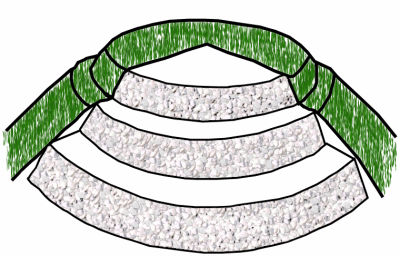
These photos can be seen on the http://www.stone-circles.org.uk/stone/silbury.htm website. The layering at the top will remain visible the longest throughout the erosion process.
Function.
Because of the enormous effort there has to be a function. However, the purpose of the hill is not fully known. Whatever its purpose, there has never been a shortage of treasure seekers:
- In the course of time a lot of legends and myths have come to pass that we are quick to ignore. The fact remains that the hill was the highest structure in Britain until the Middle Ages. And the name could refer to the legendary King Sil who was buried here in his golden armour.
- Archeological research has not revealed any traces of burial chambers. Possibly it is a sanctuary, a place of sacrifice or had an astronomical function.
- During the Roman period, a settlement arose at the foot of the hill and a Roman road ran alongside it. Roman coins and pottery provide proof of this.
- In the following Saxon period, the hill was flattened and used as a lookout point. In the absence of stone foundations, it was kept on a wooden temporary structure that was therefore possibly of a defensive nature.
Archaeological research.
In modern times, the hill has been explored several times:
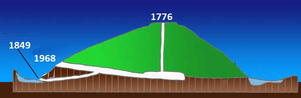
- In 1776, miners dug a vertical shaft in the middle of the hill. They were looking for a central burial chamber, but they found nothing.
- In 1849, a horizontal tunnel was drilled at ground level. But even then, no burial chamber was found, only a few obscure organic remains.
- A third major excavation was carried out by Professor Richard Atkinson in 1968 and 1970. He carefully examined the two previous tunnels and commissioned a third. But once again the result was virtually nothing:
- Flint tools.
- Antlers.
- Animal bones.
- All these ill-considered interventions (especially not filling the corridors again) led to the collapse of the top of the hill and the opening of a 15 m deep crater in 2000. It cost a lot of money to close the opening with the help of a helicopter, but it resulted in a nice report for the BBC.
This photo can be seen on the http://isida-project.org/england_2014/silbury.htm website. Three drastic courses were unsuccessful.
Since 2007 the hill has been stabilised again. Through incoming cosmic radiation (muons) one tries to find out a bit more about its contents and in the process one has left the really drastic actions, which may have done more harm than good. This is based on the experience gained in the archaeological research of some pyramids in Egypt.
Trivial functions.
The official name Silbury Hill Round Barrow contains a reference to a burial mound. This is clearly a mistake. In the search for another reason to build the hill, two possibilities have emerged recently:
- The first possibility is rather daring. The hill would have been a few metres higher in the past. The top has been rained down, as it were, this is possible. A metal rod would have been placed on it then, which served as a lightning rod. The electrical discharges to the ground made the earth ionise. The inner skeleton of lime provided good conduction. The acidic environment became (temporarily) more basic and in this environment plants could get their nutrients and thus grow better. This process and thus better agriculture would have its effect on about 16 square kilometres. Say only 4 km on 4 km and with that the whole Neolithic settlement is covered. The fact that the hill is less high today reduces the risk of a lightning strike. It is thought that The White Horse may have taken over that function in the area. And so we get an explanation for the White Horse phenomenon in this area.
- The second possibility is a little too ordinary. The river West Kennet follows a capricious course here. On several places this river is fed by underground wells. Almost a dozen have been found near the southern edge of the hill. By excavating that area, they created a ditch, a fresh water basin, a water supply. It is handy to pile up the excavated material in a hill. So it is possible that people were just looking for water.


Comments